
Search results
BEBOP

Parrot
BEBOP
Parrot
Fitted with a 14 mega-pixel camera with fisheye lens, the Parrot Bebop Drone can produce videos in Full HD 1080p with a 180 mobile camera. Boasting fully digital image stabilising technology, the Bebop Drone films during flight, whatever the movements inherent in the quadricopter.
BEBOP-PRO 3D MODELING
Parrot
BEBOP-PRO 3D MODELING
Parrot
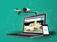
Parrot Bebop-Pro 3D Modeling is the all-in-one drone solution for architects, building professionals and real estate agencies to easily create photorealistic 3D models, photos and videos of houses and buildings. This multipurpose tool is a unique combination of Parrot Bebop 2 Power and the Pix4Dmodel software solution, enabling building professionals to quickly and easily assess the work to be carried out. With this solution they can draft new projects and promote their properties on the web.
The first turnkey drone solution for 3D modeling
There’s no need to be a seasoned pilot, as Parrot Bebop-Pro 3D modeling can be used by everyone. You don’t need any prior knowledge of drones or 3D modeling. Pix4Dmodel is one of the most comprehensive and powerful software on the market, with which you can obtain a 3D model with impressive rendering from the 14 MP photos taken by your drone. To make taking these photos easier, the Parrot Bebop 2 Power drone is programmed for an entirely automatic flight; simply use a smart device and the Pix4Dcapture application.
No Need To Be a Seasoned Pilot
Light and compact (500g) Parrot Bebop 2 Power is safe in flight, robust and easy to transport. Its 14MP camera ensures optimal shots and Full HD 1080p videos. All you need is a smart device to control it. Its 25 minute battery life lets you get the job done without fear of running out of battery mid-flight. With the Pix4Dcapture mobile application, send the drone on an autonomous flight around a property or a construction site.
A field tool for architects and building professionals
Parrot Bebop-Pro 3D Modeling is an easy-to-use solution for quick visual inspections and drafting structural work on a property. This drone solution can be used to make immediate decisions about the work to be carried out. You can easily get a building's measurements, such as the length, height or surface area of a roof. Before starting any work, you have the relevant data to hand to estimate the scope of the work to be done, from painting walls to replacing a roof.
Innovative solution to present properties to customers
Using a 3D model of a property to promote real estate is both new and innovative. Much more effective than a video, buyers can discover a property virtually on their screen. They can take a look around the house and view the surrounding environment from all angles.
Imagery and 3D processing for media, both at the office and on the go
The Pix4Dmodel solution incorporates several tools to make the 3D imagery experience of your property as comprehensive as possible
Using the Pix4Dcapture mobile application, plan your flights and retrieve all images necessary for mapping. With the web publication module or directly from the application, send these images to Pix4Dmodel cloud, automatically generating a 3D model. You can share this unique content on your site and your social networks to showcase your properties.
DISCO FPV
Parrot
DISCO FPV
Parrot
Enjoy an unprecedented flight experience
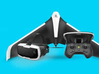
The Parrot Disco FPV combines all the latest high-tech essentials for flights with exceptional reality. Discover the Parrot Disco, the first smart flying wing to reach 49.71 mph. Immerse yourself in the sky's vastness and see the world from a whole new angle with Parrot Cockpitglasses, the essential goggles for immersion flights. For total control, fly your wing with precision with the new Parrot Skycontroller 2. Take control!
Fly, spin, and glide without stopping
With its aerodynamic design, streamlined look, fixed wings, light carbon and EPP (expanded polypropylene) body, the Parrot Disco is naturally designed to fly like a plane. With the Parrot Cockpitglasses, discover FPV (First Person View) for fully immersive flights. Alternate between straight lines and turns, take time to glide and enjoy the view, then pick up speed, dive down and climb back up. Extreme flight sensations guaranteed.
Change perspective
With Parrot Cockpitglasses, feel the ultimate immersive flying sensation. The Parrot Disco drone comes with a 1080p Full HD front camera stabilised on three axes for video feedback via your FreeFlight Pro app. Just put your smartphone in the Parrot Cockpitglasses and it's as if you were flying, with the skyline changing when you turn. Spread your wings and experience the most incredible flights!
Fly faster, for longer
With the Parrot Disco, reach 49.71 mph with its powerful motor and enjoy the experience for longer: a high-capacity battery guarantees up to 45 minutes of battery life. Flown from the new Parrot Skycontroller 2, it has optimised secure Wi-Fi connection with live video feedback on your smartphone via the FreeFlight Pro app. More than ever, the sky is yours... so how far will you go?
Fly easily and accurately
With the Parrot Skycontroller 2, use two joysticks for an ultra-precise flying experience and fly your Parrot Disco up to 1.24 miles away! Take off and land with a single click. Go on adventures and return to the starting point on autopilot, or play with altitudes and speeds. The anti-stall system guarantees stability. Change directions, film long scenes thanks to 32 GB of internal memory, and modify control settings: you're at the helm of truly intense flights.
Download, and you're ready to fly immersed
Free Flight Pro is an app dedicated to advanced flight with drones. The interface was designed for you to use with FPV glasses and enjoy total immersion. All your routes, photos, films and data are saved. You can find them easily and share your feats on Youtube. With this edition, you can access Flight Plan, a fee-paying solution for creating highly precise autonomous flight plans (altitude, speed, camera angle, etc.). Now, get started!
DISCO-PRO AG
Parrot
DISCO-PRO AG
Parrot
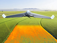
Parrot Disco-Pro AG is the all-in-one multipurpose drone solution for farmers that fits in their tool box to help them improve the ROI of their crops. Thanks to its turnkey solution, Parrot allows farmers to monitor their crops from the air by conducting drone flights that require no knowledge of flying. Equipped with state-of-the-art technology, the farmer can easily control his device to analyse up to 150 ha of data per week via NDVI maps and generated zonings. Radiography of unprecedented precision to draw up an inventory of the various plots of land.
Easy to pilot and reliable drone solution
With its enhanced aerodynamic design and its advanced autopilot, Parrot Disco-Pro AG is easy to pilot, reliable and safe. This fixed wing drone solution comes with a powerful motor and a high capacity battery that covers up to 80ha / 200ac at 120m / 400ft flight altitude in a single flight. The new Parrot Skycontroller 2 ensures an optimized and secure Wi-Fi connection, and live video streaming on your smartphone via the FreeFlight Pro app.
Capture crop data with Parrot Sequoia
Parrot Sequoia is a cutting-edge multispectral sensor for precision agriculture.With its two sensors, multi-spectral and sunshine, Parrot Sequoia analyses plants' vitality by capturing the amount of light they absorb and reflect. When facing downwards, the high precision multispectral sensor captures RGB photos and the light plants reflect in four separate bands: green and red lights and two infrared bands invisible to the human eye. When placed on the drone facing up, the sunshine sensor records the intensity of light emanating from the sun, so you can perform radiometric calibration to ensure consistent data measurement.
Analyze your crops with AIRINOV First + NDVI maps
AIRINOV First + is the powerful and easy-to-use agricultural cloud mapping platform that processes captured crop data into actionable insights. All it takes is 3 simple steps; create your account, upload your photos to the cloud and generate your actionable AIRINOV report. The AIRINOV report gives you insights on your crops by processing up to 150ha / 370 acres per week and includes:
- NDVI maps: the easiest way to measure intra-field variability
- Simple zoning map for a quick analysis
- Detailed zoning map to help estimate Variable Rate Application
ANAFI EXTENDED
Parrot
ANAFI EXTENDED
Parrot
The flying 4K HDR camera complete with accessories that you can take everywhere on the go
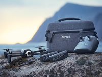
ANAFI, the flying 4K HDR camera comes complete with a travel kit that includes:
- ANAFI, the flying 4K HDR camera
- Parrot Skycontroller 3, the long-range controller
- 2 additional smart batteries + USB type C cable, giving you a flight time of 1 hour and 15 minutes
- An ultra-compact travel bag created especially for ANAFI Extended
- 4 foldable propeller blades
- Two-month membership to Adobe Creative Cloud for photos or Adobe Premiere Pro CC to make your shots that much more striking
Show off your creative flair with a 21MP camera, unique shots of 180°, a 3x zoom and an impressive Hyperlapse mode. Make your photos stand out with Adobe Creative Cloud.
Everything you need in a travel case
ANAFI comes complete with an ultra-compact travel bag tailor-made for ANAFI Extended. The bag can contain the Parrot quadcopter, Parrot Skycontroller 3 and two additional smart batteries, providing 1 hour and 15 minutes of flight time. Thanks to its on-the-go charging system, you can charge your batteries using a power bank (not included).
Show off your creative flair
ANAFI is an ultra-compact flying camera with professional capacities, created to make sure you stand out from the crowd. Versatile with extreme precision, ANAFI and its lossless zoom lets you capture spectacular footage in all lighting conditions.
Simply stunning images
Get it right first time thanks to the powerful artificial intelligence and ergonomics of the FreeFlight 6 application. With this application, drone pilots of all levels can easily shoot footage from the sky. FreeFlight 6 includes the new Panorama modes including 360° Sphere, 180° panorama and Little-planet (panorama modes available late November).
One of the quietest and sturdiest drones on the market
Capture memorable moments even when you’re out enjoying your most extreme adventures. ANAFI was made to resist difficult weather conditions thanks to its carbon reinforced frame and athermic camera that resists temperatures from -10° to +40°. The powerful motors can resist winds of up to 33mph. All that encased in one of the quietest drones available on the market.
The pack contains:
- 1 Parrot Anafi Drone
- 2 additional Smart Battery
- 1 Parrot Skycontroller 3
- 1 compact travel bag
- 16 GB Micro-SD card + SD adpter
- 3 USB-A to USB-C cable
- 8 additional ultra-quiet propeller blades
- 1 Mounting tool
MAMBO
Parrot
MAMBO
Parrot
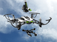
The Parrot Mambo minidrone is full of surprises! Whether you equip it with the Cannon or the Grabber, it'll turn the sky into an amazing playground. Speed or skill races, acrobatic challenges or tricks... take on any aerial combat. Highly robust and easy to handle, it'll rise to all your challenges.
Test your skills
Solo or in a team, it's now time to head off on a combat mission. Attach the Cannon to the Parrot Mambo and let the game begin. Target your opponents' drones or try games of skill, such as firing at a pyramid of beakers or bringing down light-weight targets. You can load up to six balls. They're harmless, so give it your all to win the match!
Become a transporter
Fancy doing something out of the ordinary and surprising everyone? Attach the Grabber to the Parrot Mambo and use your imagination: anything is possible... The grabber can pick up objects (up to 4 g), carry them up into the air and put them down wherever you want.
Make the most of a simple and effective control system
Thanks to an advanced flight controller and high-performance sensors, the Parrot Mambo is easy to control... so easy that even if you stop using the controls, it remains stable! The autopilot takes over. But wait, there's more: activate the cut-out system and the motors will automatically stop in the event of a crash. The only limit is your imagination!
It's time for exciting flights and aerobatics!
Reverse, rotate, flip in both directions and even perform a magical take-off from your hand: all maneuvers are possible with Tynker's code blocks. You're at the hem, so enjoy the thrills and code your Mambo to avoid obstacles, slalom between posts or be the fastest pilot. Or attach the Grabber and program your Mambo to pick up objects (up to 4g) and move them wherever you command. The choice is yours!
Download, and you're ready to have fun
With a completely friendly user interface, a simplified first log in and automatic recognition of your connected drones and accessories, everything has been thought of to let Free Flight Mini expand your options for playing and experiences. Change your minidrone's flight settings and check the remaining battery and flight time. Let your imagination run riot and blow your friends away...
What's included:
- 1 Mambo drone
- 1 Cannon
- 1 Grabber
- 1 USB cable
- 50 Cannon balls
- 1 Quickstart guide
BEBOP 2 POWER FPV
Parrot
BEBOP 2 POWER FPV
Parrot
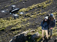
Parrot Bebop 2 Power is the latest drone of the Bebop generation and the most advanced of Parrot’s consumer quadcopters. With 60 minutes battery life (2 batteries), FPV goggles and a new flight assistance system, it offers even more freedom to explore the world. Explore, take photos and capture videos - experience no limits, time belongs to you!
Fly for longer
Enjoy the best battery life on the market for a consumer drone!With more than 30 minutes of flight time per charge and a range of up to 2 km with the WiFi HD 720p transmission system and the Parrot Skycontroller 2, you can push the limits of your aerial exploration. Thanks to ideal aerodynamics and an optimised propulsion system, the Parrot Bebop 2 Power can fly up to 65km/h in sport mode and can resist winds of up to 60km/h.
Film like a pro with flight assistance
Making top-quality videos with a drone has never been easier.Parrot Bebop 2 Power’s intelligent flight modes let you capture perfect aerial videos the from the get-go. With a simple click, launch auto-shots such as 360° panorama and various travelling camera motions with simultaneous camera movement and Magic Dronies: Orbit, Tornado, Parabola or Boomerang - ideal for filming yourself.
Capture high-quality images
- Custom-made lens: Parrot Bebop 2 Power includes a custom-made wide-angle lens and an advanced anti-distortion system for top-quality aerial image capture.
- Three-axis digital stabilisation: Patented 3-axis digital stabilisation guarantees images with remarkable stability by reducing vibration and aliasing.
- 14 MP Camera: A 14MP CMOS 1/2.3" camera lets you shoot in Full HD 30fps and take JPEG and Adobe DNG RAW photos for post-production image editing.
Change perspective
Put on the Parrot Cockpitglasses 2 for an immersive flight experience. Prepare yourself for a thrilling ride! Easily switch to Direct view to see your drone, without taking off the Parrot Cockpitglasses 2. How convenient is that!
With Follow Me, you're in the heart of the action
Capture the greatest moments with precision, thanks to an innovative use of visual recognition technologies, GPS tracking data and your smartphone’s barometer. Bike riding, running, rowing, climbing... Anything is possible! Just slip your smartphone into your pocket and let the drone capture the action. The “Follow Me - Visual and GPS tracking” feature is included in the Parrot Bebop 2 Power pack.
Both elegant and rugged
Parrot Bebop 2 Power’s new DUAL BLACK design combines two sleek finishes; matte black and glossy black. The drone's structure is a blend of carbon fiber and Grilamid. The latter is a lightweight plastic used in the automative industry and is renowned for its extreme resistance.
Fly safely
Parrot Bebop 2 Power embeds GPS + GLONASS satellite tracking technology and optical ground recognition to guarantee stability and safety during all flights.
- Locate my Bebop: If you can’t seem to find your drone, Locate my Bebop lets you locate it on a map.
- Return Home: Upon request or if connection is lost, the drone can automatically return to its take-off point.
- Geofence: Define a flight zone within which your drone can continue to operate, but with set limits that cannot be passed. When your drone has reached the set limits, the drone will continue to hover at the same altitude enabling you to take control.
Download, you are cleared for take-off
FreeFlight Pro is the free mobile app dedicated to your Parrot drone. It takes just one touch to fly, film and easily share your aerial photos and videos. With Smart Flights, you can get assistance while taking photos enabling you to get the perfect shot. FreeFlight Pro lets you experience an immersive flight and is designed to function with your Parrot Skycontroller 2 and the Parrot Cockpitglasses 2. Also be sure to try Flight Plan and Follow Me, two paid features which let you use 100% of your drone’s potential. Finally, log in to My.Parrot from your app to have a look at your flight data!
What's included:
- 1 Parrot Bebop 2 Power
- 1 Parrot Skycontroller 2
- 1 Parrot Cockpitglasses 2
- 2 Power batteries
- 4 propellers
- 1 charger + cable + 4 plugs
- 1 assembly tool
- 1 USB cable
- 1 smartphone and tablet support
- 1 quick start guide
BEBOP-PRO THERMAL
Parrot
BEBOP-PRO THERMAL
Parrot
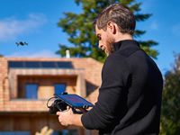
Parrot Bebop-Pro Thermal is a quadcopter that allows architects, builders, roofers and real estate agencies to safely carry out inspections with its 2 embedded cameras.
This easy to use and accessible solution enables you to make videos and take pictures of buildings and roofs in visual or thermal images, quickly providing an overview and identifying major thermal losses.
The new FreeFlight Thermal mobile app provides live streaming and recording of both the visual and thermal images on a smartphone or tablet connected to Parrot Skycontroller 2.
Quickly and easily locate major thermal losses on roofs
By capturing thermal images, it is possible to identify the temperature differences on a roof and locate areas with bad thermal insulation. Using a drone makes it safer for a roofer to carry out a thermal analysis of a roof from the sky.
Get an overview of the thermal envelope of a building at a glance
With this solution, it is possible to safely identify thermal irregularities on the envelope of a building. It is even possible to analyze inaccessible areas with ease.
Multipurpose and easy to use drone
Parrot Bebop-Pro Thermal is light (604 g), robust, safe and easy to carry. The front 14 MP camera enables you capture high-res photos and Full HD videos 1080p. With Parrot Skycontroller 2 you can fly the drone exactly where you want, giving you the opportunity to inspect even inaccessible areas. Thanks to its Power battery, the drone can fly up to 25 minutes.
FreeFlight Thermal is the new mobile app dedicated to Parrot Bebop-Pro Thermal
FreeFlight Thermal is free mobile app and is only compatible with Parrot Bebop-Pro Thermal. The mobile app is available on the Google Play Store and compatible with Android tablets.
Features:
- Visible photo and video streaming and recording
- Thermal image photo capture and video live streaming
- Switch between visible camera and thermal camera at any time
- 3 color pallets available to serve different use cases: Standard, Dynamic and Hotspot
What's included:
- 1 Parrot Bebop-Pro Thermal
- 1 FLIR ONE Pro camera
- 1 Parrot Skycontroller 2
- 3 batteries
- FreeFlight Thermal App
- 1 backpack
BLUEGRASS
Parrot
BLUEGRASS
Parrot
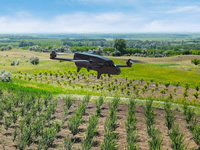
Parrot Bluegrass is a multipurpose quadcopter designed for agriculture. It helps farmers improve their ROI using its 2 embedded cameras; video camera and Parrot Sequoia multispectral sensor.
With its Full HD front camera, this solution includes visual monitoring of land, herd and infrastructure. It also provides a quick and easy analysis on the health of your crops, thanks to its user friendly processing software, AIRINOV FIRST+.
Parrot Bluegrass is easy to transport due to its removable propellers and it is easy to: set up, fly, process data and repair.
Find out more about the health of your crops
Parrot Bluegrass is equipped with a multispectral sensor, Parrot Sequoia. This small and light multispectral camera captures 4 spectral bands in visible light and non-visible infrared light to analyze the health of your crops. Parrot Sequoia has a 16 MP RGB camera and an internal memory capacity of 64GB.
Parrot Sequoia also comes with a sunshine sensor that records the current lighting conditions, the GPS location and inertial data. The data captured can be used in various processing software such as Pix4Dag or AIRINOV FIRST+ cloud platform. The software generates an index map of the field, enabling you to monitor and scout crop that needs optimized treatment.
Multipurpose drone for your farm
Designed to be easy to use and pilot, Parrot Bluegrass is a combination of an aerodynamic design, advanced autopilot, powerful engines and a high capacity battery.
Using Parrot Skycontroller 2 with Parrot Bluegrass you can execute very precise flights in a range of 2km (1.2 miles). The quadcopter transmits videos shot using its front camera to the controller, allowing you to inspect your farm, monitor your herds and get an overview of your land.
Automatic crop mapping of each plot using Pix4Dcapture
Pix4Dcapture is a simple app that allows you to plan automatic flights above your land.
The interface enables you to accurately define the area you want to fly over and at what altitude, so you can closely follow the status of your flight.
Parrot Bluegrass can cover up to 30 hectares at 70 m / 230 ft. flight altitude.
Pix4Dcapture: flight planning mobile app
Pix4Dcapture is a mobile flight planning app to optimize mapping data from your consumer drone.
This free app created by Pix4D software lets you select a flight plan and capture image data, ready to create georeferenced maps and models in Pix4D desktop software.
Available for Android and iOS.
With AIRINOV, experience a fast and easy service
AIRINOV is an agricultural services company made up of agronomy experts, whose aim is to help farmers monitor their fields and researchers their trial platforms. Thanks to its 6 years’ experience focusing only on agriculture, AIRINOV knows expectations and delivers best-in class products. More than 15,000 farmers already use this service worldwide.
AIRINOV First + is the powerful and easy to use agricultural cloud mapping platform that processes the captured crop data into actionable insights. All it takes is 3 simple steps; create your account, upload your photos to the cloud and generate your actionable AIRINOV report.
The AIRINOV report gives you insights on your crops by processing up to 150ha / 370 acres per week and includes:
- NDVI maps: the easiest way to measure intra-field variability
- Simple zoning map for a quick analysis
- Detailed zoning map to help estimate Variable Rate Application.
What's included:
- 1 Parrot Bluegrass
- 1 Parrot Sequoia
- 3 batteries
- 1 Parrot Skycontroller 2
- 1 backpack
- 2 chargers and 6 adapters
- 1 USB cable for Micro-USB
- 1 quick start guide
- 1 year of AIRINOV FIRST+ agriculture mapping cloud platform
- 1 month subscription for Pix4Dag – used on desktop and cloud