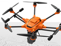
Part Number: H520 RTK
Description
One of the fastest RTK systems in the world
The commercial Hexacopter H520 receives one of the fastest and most reliable RTK systems in the world, developed by the award-winning Swiss company Fixposition. Fully integrated into the H520, it ensures the highest precision and the fastest possible operational readiness even under difficult GPS conditions like in cities, canyons or forests. Thanks to Real Time Kinematics satellite navigation the new H520 RTK will be able to stand in the air with centimeter accuracy, enabling extremely precise, repetitive photos, faster 3D mapping and more accurate, even automated, inspection flights.
Available as a complete system or as an upgrade
The H520 RTK will not only be available as a complete system - your existing H520 can also be upgraded by our service team to a RTK version, with the same technical features as the complete system.
2 components for a centimeter-level positioning
The system works with 2 components, an RTK module on board of the H520 and a base station. In less than 30 seconds it can reach a centimeter-level accuracy, also under challenging GPS conditions (with respect to the base station). For an absolute global centimeter-level accuracy and in case you don't want to use a base station, the system can also be operated with a network RTK reference station (Network RTK through third party provider, needs an internet connection, additional fees may apply).
Real Time Kinematics - Application areas
The RTK system is an important part of commercial applications where highest precision is required. A classic field of application is 3D mapping, for example with Pix4D, Dronedeploy or Altizure software. With the help of RTK, there are significantly lower image overlaps which means that less photos and thus a shorter flight and calculation time are necessary. In addition, inspections can be much closer to the desired object because the drone's location will be precise down to the centimeter. This precision is also a great advantage when comparing several images taken on different days, for example to document a construction progress.
Mission ready
The RTK module enables precise positioning even in challenging environments and is fully integrated into the H520, hardware and software wise. This means that you still have the full range of functions of the award-winning DataPilot software. All data, including raw GNSS data, can be logged on board. Thus, the system is also already for PPK (Post Processed Kinematics).
Features:
- RTK (Real Time Kinematic) module for high accuracy relative positioning: 1 cm + ppm horizontal / 1.5 cm + ppm vertical
- Keep cm precision in even GNSS challenging environment (e.g. between high buildings)
- For faster and more precise mapping (e.g. complex surveying, inspections, mapping, 3D displays)
- 5 Hz update rate of position, velocity and time
- Fully integrated to YUNEEC H520
- All data including raw GNSS data and real time solution can be logged on board - ready for PPK (Post Processed Kinematics)
- Support signals of up to 3 GNSS constellations among GPS, GLONASS, Galileo and BeiDou
- Compatible with all existing Yuneec H520 camera payloads
- Network RTK or Base Station needed
- RTK module available separately or in combination with
the H520 (The separate purchase of the module requires
professional installation by the Yuneec service team)